
|
My alarm went off at 05.00 UT, it was the pre-dawn hours of February 5th and my first storm chase of the new year. There's no better motivation for getting out of a sung bed on a cold Winter's morning during stupid o'clock than the prospect of capturing convection. To be honest I never had high expectations and was fully expecting to get very little however after so much bland weather the thought of a chase and adventure was exactly what I had been craving.
A convective cold front had passed through the previous evening, the line itself had experienced major shear and as a result the front was expected to have squall line elements with a risk of a rogue tornado embedded in rain, of course all of this was to take place after dark and wouldn't be a visual event however it still warranted watching on radar. The radar malfunctioned over N. Ireland exactly during the front's passage however I later learned the Mid-Ulster area had an insignificant event other than heavy rain, the line was more intense below the border and power was knocked out in Coalisland by strong wind gusts then the front cleared to introduce phase two of the set-up.
The post-frontal air mass would advect in overnight dragging colder and increasingly unstable air. Upper air was -30c combined with a swift NWly flow with more than 40 knots of deep layer shear overlayed with 50-100 SB CAPE. The result would be swift moving scattered convective showers with a chance of thunderstorms, wintry in nature, with snow on the hills inland. The only problem was that the unstable air would peak between 06.00 to 09.00 with lesser instability until midday, this would mean a very early chase under the cover of darkness, there would be no moonlit to illuminate cells so I would have to wait until dawn to get a proper visual on the clouds. The models all indicated the N and NW coasts as prime locations for convection. I was discussing the potential with Nigel McFarland and Colleen Webb the previous night and we all agreed to meet at sunrise for a combined chase. Later I had almost completely talked myself out if it, the shear was excellent however the low end CAPE combined with the short window period during daylight to see anything had me trying to justify the trip. However, I quickly justified it to myself, with that caliber of shear any cells would be organised and tilted with potential for funnel clouds and waterspouts, and these have happened in recent years over the ocean during these cold set-ups so this in itself was motivation to set alarm.
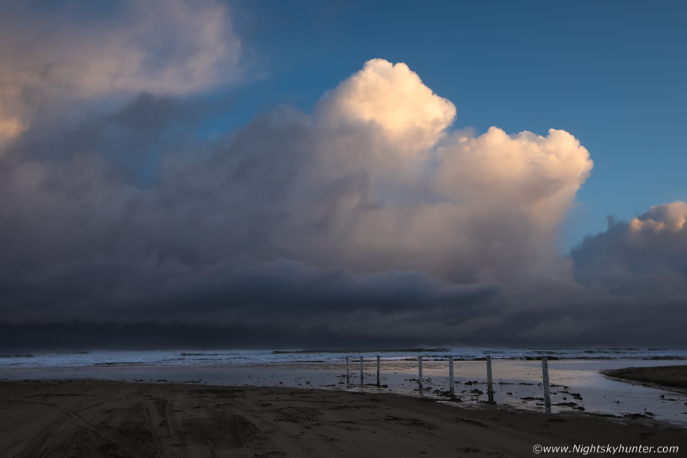 |
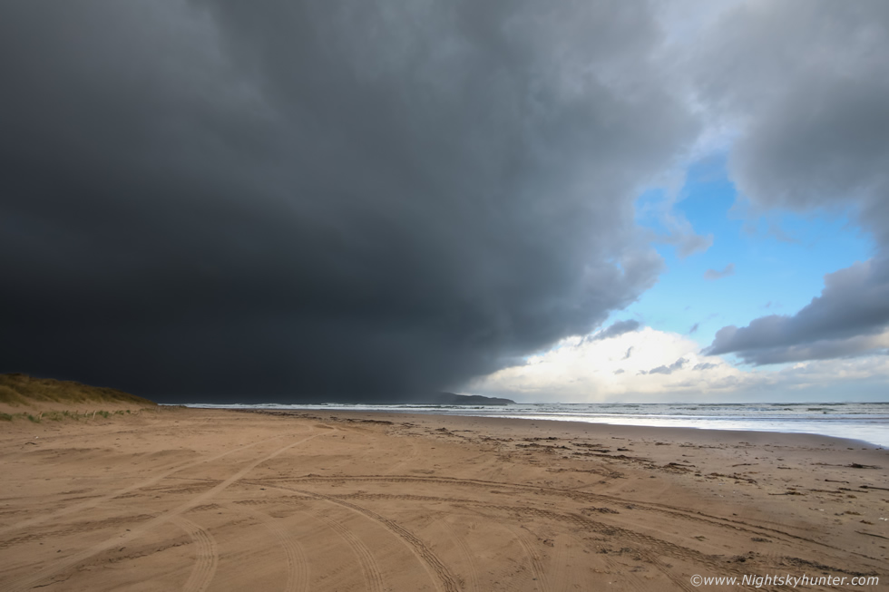
I packed supplies then at 05.30 UT hit the road then by 07.00 UT I had arrived at the north coast, we had chose Benone Beach as our storm watching location. At first light I began to see cells appearing then as the first rays of the rising sun cleared the horizon they illuminated the tops of these towering cumulus, these were developing nicely on the front of a very large dark cell coming into view just as the best instability was moving into this area.
 |
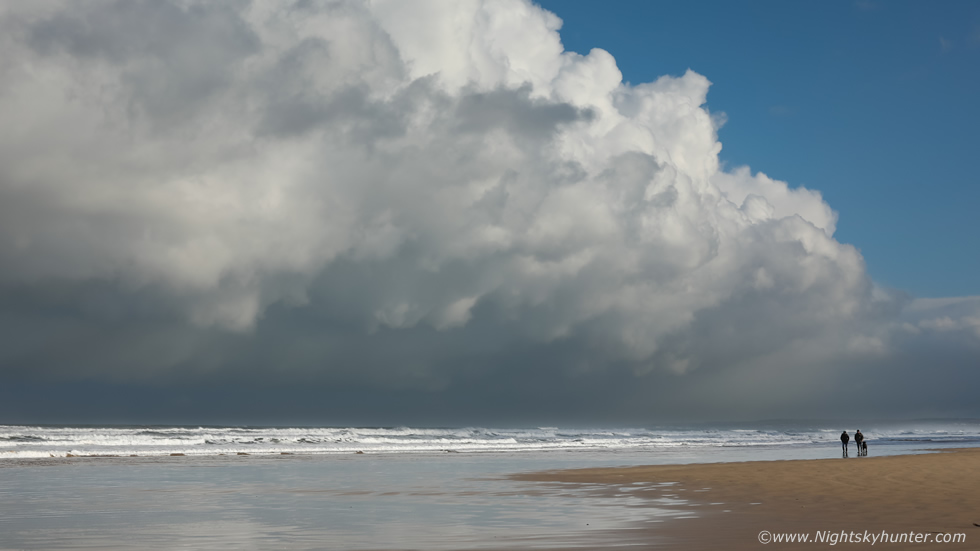
We made our way onto the wind-swept dunes as the sun peaked out from behind a bank of clouds to the E. To our NW was this massive cell which had engulfed Donegal which was worthy of an image, this was 15mm wide angle on full frame, Nigel and Colleen can be seen in the foreground. When the cell hit it delivered a squall of rain and hail, once it passed the sun came back out and another cell was blowing into view and this one was in full glorious sunshine.
 |
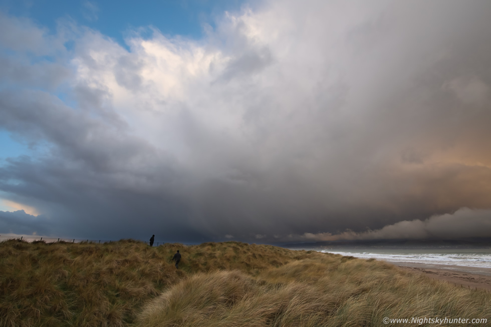
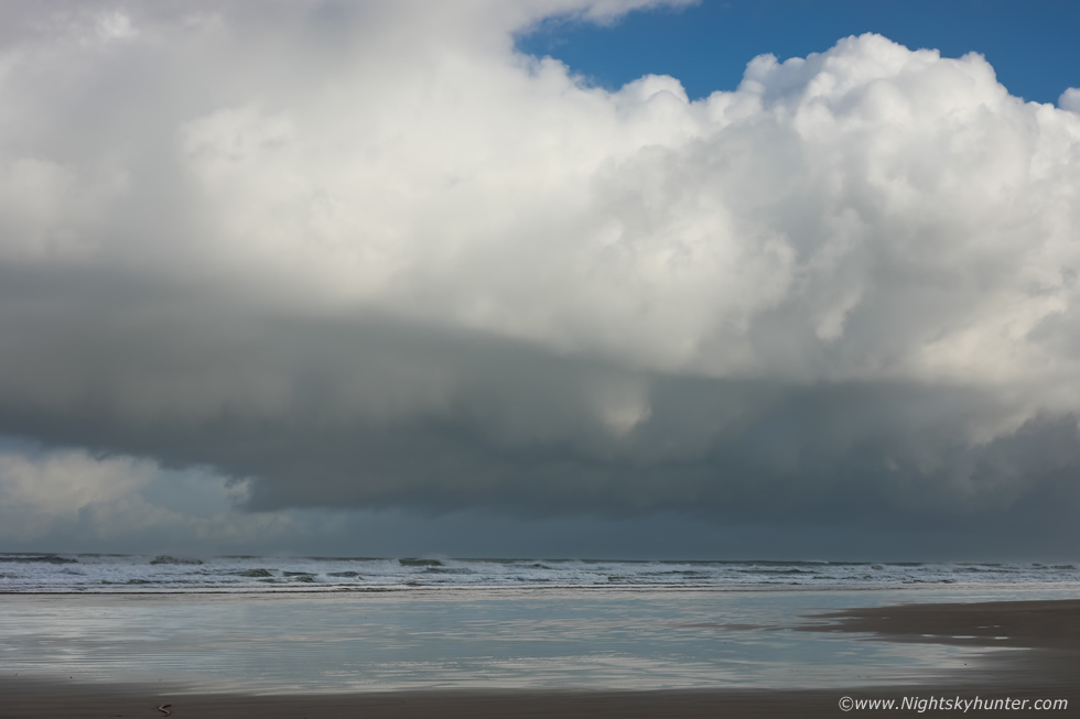
We ran back onto the dunes and made our way deeper across the complex to get a good open horizon, our new cell had soon become the star of the show as it began to unleash a huge curtain of hailstones, moving towards us and somewhat to the left. I began shooting a time lapse here and knew it had the potential to be quite stunning however I ended up having to bin the render I made as the spongy grass had caused the camera to shake in the wind gusts, but I at least had the still images to keep.
 |
Hail curtains sweeping over the wild grass at sunrise, just us and nature, no one else about, this was invigorating and I was already glad I had made the decision to chase, even this was reward enough for the the journey.
 |
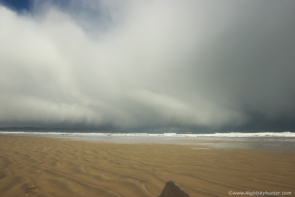
We had a quiet period with no action so we spent time chatting on the beach, eating snacks or having a brew from the flask. I was having issues with my new tripod ball head base plate, there seemed to be slight motion where it connected with the battery grip on the 5D, even the shake from the shutter clicking when shooting time lapse was causing the camera to shake which was ruining all my time lapses. Nigel took a look at it and using his supply of tools he got the micro screws tightened which seemed to help, I was about to test it out and grabbed the camera, turned around, and saw this. We were about to be overrun with this beast of a cell, pure black and brutal looking, how it sneaked up on us so quickly I will never know. I ran down the beach and shot five wide angle images hand held before it hit us, a period of nasty wind-driven hailstones and strong outflow gusts ensued. Thanks to the strong flow aloft the cell passed through quite rapidly and we were lit by the sun once more and ready for the next one.
 |
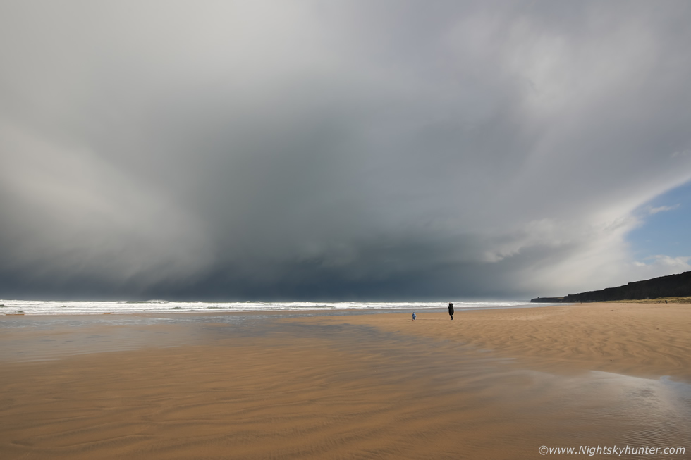
We got treated to another train of cells, it's amazing how fast they can suddenly appear then be rite on you, we watched their anvils grow over the ocean on the far side of Donegal then in no time they crossed the sea in front of us dropping their cascading curtains of hailstones. I shot two time lapses here, both at wide angle, 15mm on full frame and 10mm on crop sensor.
 |
Leading edge of the primary cell, moving L to R across the ocean, in the distance in the clear air is another distant Cb with anvil. Once this cell passed we saw two distant anvils far out to sea, easily more than 100 miles away, both had obvious overshooting tops indicating very strong anvils, accompanied of course by back-sheared anvils, if you think about it, the winds at the height of the anvil were pushing over 40 knots (46 mph) it would take a very strong updraught to push air backwards into that flow to form the back-sheared anvil. It always strikes me as strange and rather frustrating that we get our strongest wind shear during Winter yet very little or none at all during prime Summer when we have our strongest solar heating and highest CAPE values, hence why the strongest tornadoes in Ireland are documented during Winter.
 |
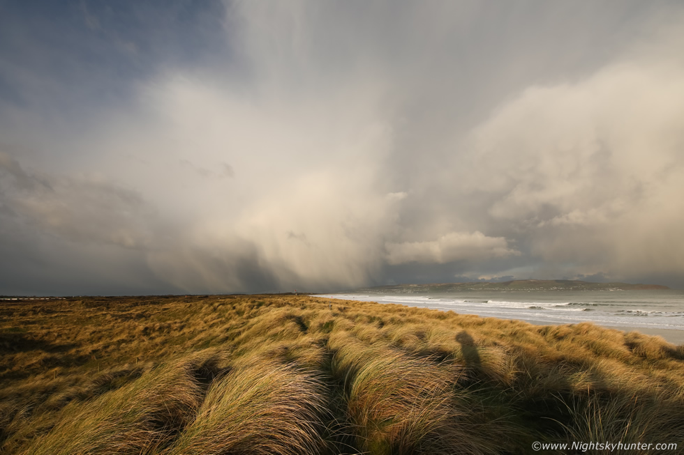
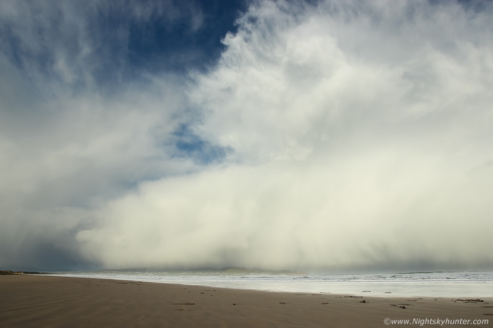
A clearance and quiet period calmed the action down for a while then between 11.30 and noon what I consider to be the best scene of the day unfolded. A tidy line of low topped towering cumulus formed over the sea, it began growing in horizontal extent and each updraught became more vigorous, even though it wasn't spectacular it was pretty enough to warrant a few images, the line of white towers against the blue sky brought back fond memories of Summer chasing.
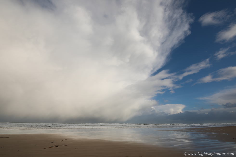
We watched with interest when things began to develop, the cells merged and the base lowered and very interesting structures formed along the base, I recall saying this is the kind of convection which can produce funnels and waterspouts. I set up two cameras, one at 50mm the other at 18mm and began shooting two time lapses. The cloudscapes were quite dramatic and despite their low tops the updraughts were clearly strongly sheared downrange, then people appeared on the beach which made for a great sense of scale. As a convective geek any cell showing strong shear, structure or an interesting updraught base ticks my chasing boxes.
 |
Another image of the same scene cropped 16x9. It was later that I learned that this very same convection had produced a waterspout, a lady captured the vortex on video off Runkerry headland, she observed that it disappeared then re-formed twice before it vanished as it made it's way eastward. The video showed no condensation funnel, or else it was located above the FOV, however the spray bowl on the sea surface was unmistakable, this was the first tornado of the year captured from N. Ireland. Considering the time of the observation and the light in the video I'm certain this was the very convection which spawned the waterspout, and looking at the protrusions along the base it was hardly surprising that such an event did happen, for this reason these two images are special to me.
 |
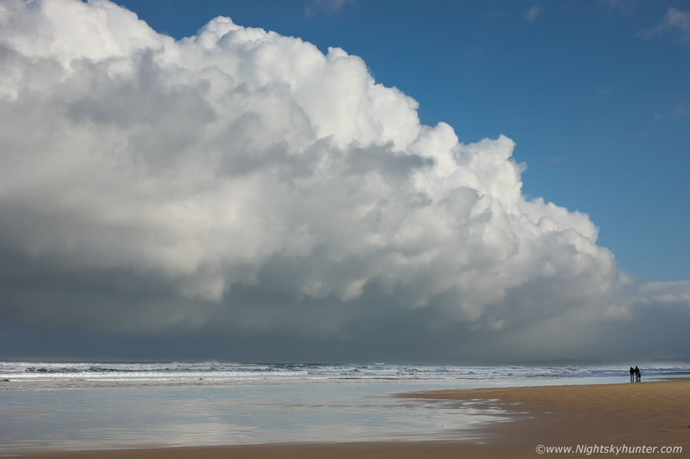
Flanking region of the same line, camera panned to the left (W) of the above image, moving L to R. This was an updraught base for certain, even the time lapse shows inflow feeding into the base, to me the entire structure we observed visually looked like a horse shoe shape, as in the base was curved, this is indicative of rotating storm, a characteristic of transient supercell structure, and given the shear this was certainly possible. I wish we had seen this during July or August in 1000 CAPE, with the updraughts being of huge size there would be a high chance of getting one or more photogenic waterspouts.
 |
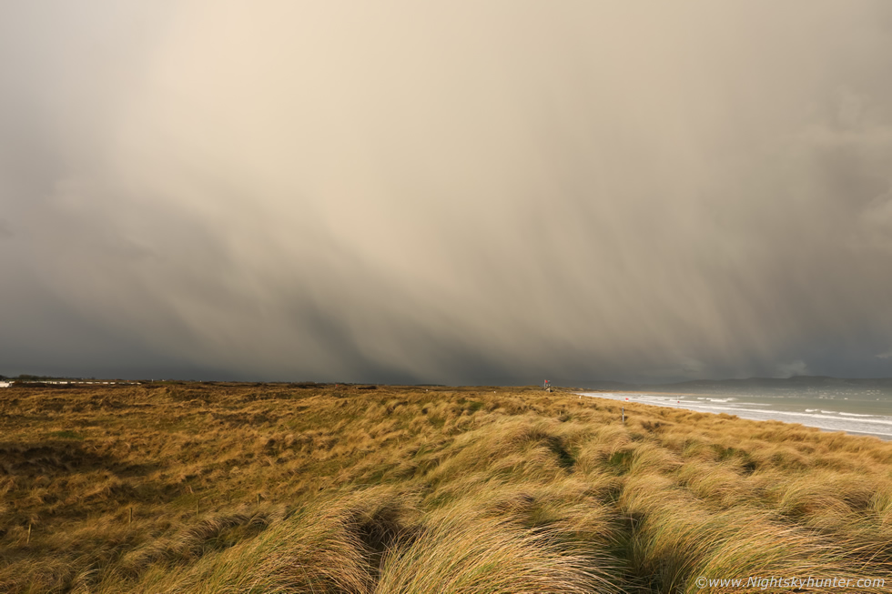
By midday the instability was supposed to weaken however the cells didn't want to hear any of it, even though they were more wispy on top they still packed a punch with big outflow gusters filled with hail. 15mm wide angle here and another time lapse sequence filmed in good light.
 |
Camera panned to the N and NE taking in the leading edge of this massive cell, good light, mean hail core and a Mother and Child on the beach enjoying themselves oblivious to what was coming in. The morning was a success with nice light, camera friendly cloud formations and a nice memory. I decided to head back inland then home to get something to eat and prepare for a night shoot, there was a slight chance of an aurora and a rare clear night.
 |
Three days earlier a C-class solar flare unfurled a long duration CME, during the course of the last 24 hours it produced two sudden sub storms and a third was brewing after dark for N. Ireland. The charts were not epic so we were not expecting a major show, but the prospect of seeing anything at all had us interested. John Fagan and I met up at Beaghmore under clear skies, the transparency was poor however the sky was usable. The N was quiet so John set up his sky tracker and I did some observing with the 10" F/5 reflector, a nice crescent moon with dark earthshine was getting low in the W. A tour worker from OM Dark Sky Park Observatory arrived with her Mother who wanted to see the aurora, so while we waited we did some casual telescopic observing. M1 the Crab Nebula, M42 in Orion, M81 and M82, the Double Cluster, M35 and comet C/2019 L3 ATLAS in Gemini at mag +9.5.
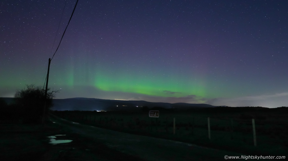
Then just as the moon was setting we noticed that the northern sky looked brighter than it should be, we pondered if it was aurora or lunar opposition effect, then suddenly vertical beams appeared in the N to NE, that's how quick it happened, from nothing to beams in an instant. We all witnessed the broad colourless rays which was a great surprise, there wasn't much time to react, I left the scope and opened the van and set up the 5D Mark IV and zoomed into 30mm F/2.8 and took three test exposures and managed to capture the beams. This was 6 sec's, ISO6400, a pity I didn't have time to find a composition and get away from that pole and wire but there wasn't time, at least I got a record of it. Then the beams vanished, they were visible for 1-2 min's at most. For the next half hour or more we watch a faint auroral arc wax and wane over the Sperrins with more spectators until the cloud came in and ended the session.
Time lapse footage of the various Cb sequences with hail outflow and of course the sheared updraught base under the towering Cu line which produced the waterspout. It felt great to get the first chase in so early in the year, it's my intention to hit chasing with more tenacity and dedication than ever before so it's all up to nature now. Thanks very much for reading.
Martin McKenna
